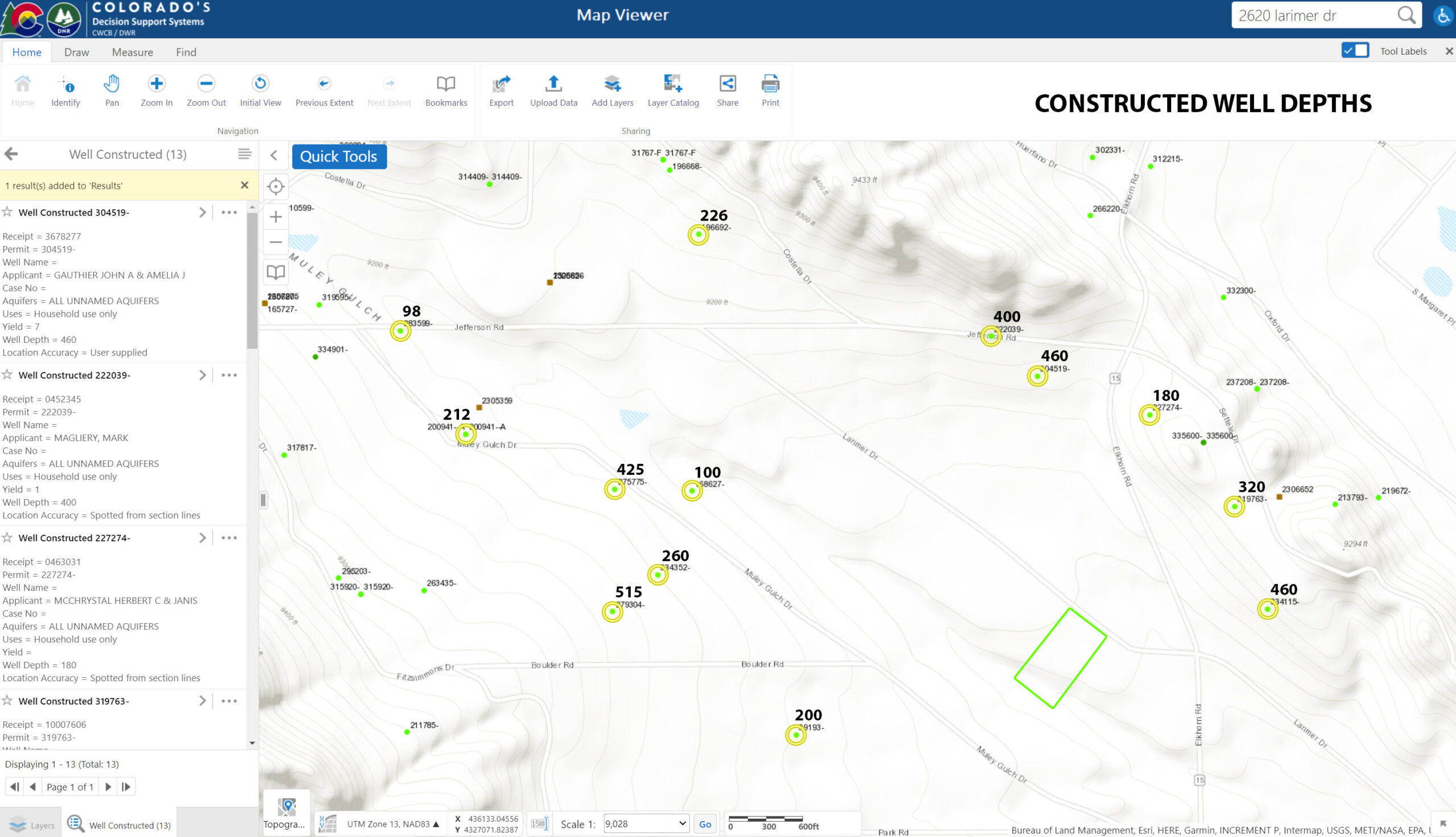
| Link | Permit | County | Filing | Lot | ParcelSize | LocAccuracy | Use1 | PermIssued | WellConstructed | PumpInstalled | WellDepth | TopPerfCasing | BotPerfCasing | Yield | StaticWL |
| https://dwr.state.co.us/Tools/WellPermits/3678277 | 304519- | PARK | 42 | 74 | 5.02 | User supplied | Household use only | 2017-02-09 | 2017-03-24 | 2017-04-13 | 460 | 400 | 460 | 7 | 300 |
| https://dwr.state.co.us/Tools/WellPermits/0452345 | 222039- | PARK | 90 | 18 | 5 | Spotted from section lines | Household use only | 1999-11-23 | 2000-02-08 | 2000-03-10 | 400 | 120 | 400 | 1 | 120 |
| https://dwr.state.co.us/Tools/WellPermits/0463031 | 227274- | PARK | 91 | 28 | 6.71 | Spotted from section lines | Household use only | 2000-07-17 | 2000-08-10 | | 180 | 140 | 180 | | 145 |
| https://dwr.state.co.us/Tools/WellPermits/10007606 | 319763- | PARK | 91 | 26 | 5.26 | User supplied | Household use only | 2020-12-10 | 2021-04-22 | 2021-05-28 | 320 | 280 | 320 | 15 | 220 |
| https://dwr.state.co.us/Tools/WellPermits/0349159 | 168627- | PARK | 42 | 34 | | Spotted from section lines | Household use only | 1993-02-24 | 1993-07-26 | | 100 | 60 | 100 | | 30 |
| https://dwr.state.co.us/Tools/WellPermits/3621435 | 275775- | PARK | 42 | 21 | 5.2 | Spotted from section lines | Household use only | 2007-10-26 | 2007-11-19 | | 425 | 385 | 425 | | 92 |
| https://dwr.state.co.us/Tools/WellPermits/10034606 | 334352- | PARK | 42 | 19 | 5.03 | User supplied | Household use only | 2024-05-16 | 2024-07-12 | | 260 | 100 | 260 | | 87 |
| https://dwr.state.co.us/Tools/WellPermits/0494835B | 200941–A | PARK | 42 | 38 | 5 | User supplied | Household use only | 2002-08-08 | 2003-04-28 | 2018-03-09 | 212 | 72 | 212 | 5 | 15 |
| https://dwr.state.co.us/Tools/WellPermits/3634768 | 279304- | PARK | 42 | 18 | 5.11 | User supplied | Household use only | 2008-11-24 | 2009-01-14 | | 515 | | | | |
| https://dwr.state.co.us/Tools/WellPermits/9050726 | 39193- | PARK | | 36 | | Spotted from quarters | Domestic | 1969-09-02 | 1969-09-09 | | 200 | 150 | 180 | | 100 |
| https://dwr.state.co.us/Tools/WellPermits/0402621 | 196692- | PARK | 90 | 7 | 6.5 | Spotted from section lines | Household use only | 1996-07-19 | 1997-06-12 | 1997-10-17 | 226 | 186 | 226 | 12.8 | 50 |
| https://dwr.state.co.us/Tools/WellPermits/10034296 | 334115- | PARK | 91 | 13 | 5.47 | User supplied | Household use only | 2024-04-17 | 2024-09-16 | | 460 | 420 | 460 | | 190 |
| https://dwr.state.co.us/Tools/WellPermits/3646106 | 283599- | PARK | 42 | 31 | 7 | User supplied | Household use only | 2010-07-21 | 2010-07-29 | 2010-09-28 | 98 | 58 | 98 | 10 | 55 |
| | | | | | | | | | | | 309 Avg | 198 Avg | 277 Avg | | |